When you need satellite imagery fast - for bushfire response, flood impact assessment, active mining operations, infrastructure construction or rapid environmental change - previous archive imagery just won't cut it. Timing is everything and the difference between a timely decision and a missed opportunity often comes down to hours.
At Terrabit, we enable urgent satellite tasking across Australia through direct access to the BlackSky Gen-2 and Gen-3 constellations inside our secure platform, Albatross. If you need new satellite imagery captured and delivered within 24 to 48 hours, we coordinate and deliver it quickly and cost-effectively - giving your team the situational awareness it needs, when it needs it.
This guide covers how satellite tasking works, when to choose urgent tasking over archive imagery, what resolutions are available through BlackSky and why daily revisit capability is transforming the way Australian organisations manage operations, risk and environmental response.
What Is Satellite Tasking?
Satellite tasking is the process of requesting a satellite operator to direct a satellite to capture fresh, new imagery over a specific Area of Interest (AOI) at a designated time. Unlike archive satellite imagery - which consists of previously captured images stored in a database - tasked imagery is collected specifically for you based on your unique project requirements.
When you task a satellite, you define the target point or area, select the resolution and set collection conditions such as cloud cover limits and off nadir angle. These instructions are sent to the satellite before it passes over your location and the resulting imagery is processed and delivered directly to you.
Satellite tasking gives you control over exactly what is captured, when it is captured and at what level of detail - something archive imagery cannot guarantee.
Why Urgent Satellite Tasking Matters for Australian Organisations
Archive satellite imagery is powerful for historical comparison, baseline studies and long-term trend analysis. But when you need visibility on what is happening right now - a developing bushfire, construction monitoring or an active mine site - you need to task a satellite for a new collection.
Urgent satellite tasking provides several critical advantages:
- Secure a new capture on your schedule. Control exactly when imagery is collected over your area of interest rather than waiting for the next available overpass.
- Prioritise your collection. Ensure the satellite acquisition occurs at the optimal time for your specific operational needs.
- Monitor change day-to-day. Track developments as they happen - site progress, environmental impact, post-disaster recovery.
- Reduce operational downtime. Make faster, better-informed decisions based on the most current data available.
- Mitigate risk proactively. Respond promptly to evolving events such as natural disasters, compliance issues or unauthorised site activity.
Instead of potentially waiting weeks for the next suitable aerial capture or satellite overpass, receive products urgently that reflect the current landscape.
BlackSky Gen-2 & Gen-3 Satellite Constellations: Built for Speed and Frequency
Terrabit provides satellite tasking through the BlackSky Gen-2 and Gen-3 constellations, which are specifically designed for high-frequency monitoring and rapid tasking.
BlackSky Gen-3 - 35cm Very High-Resolution Satellite Imagery
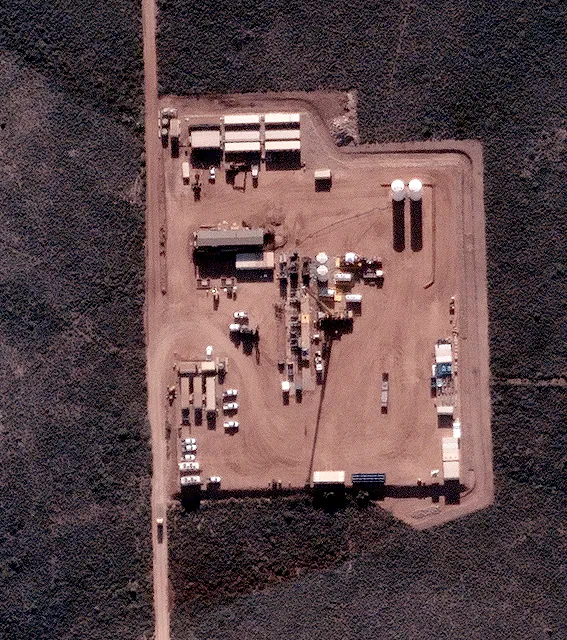
BlackSky Gen-3 delivers up to 35cm resolution satellite imagery, providing premium-level detail. At this resolution, you can identify individual vehicles, earthworks, structural changes, site expansion, road activity and equipment presence on industrial sites.
Ideal applications for 35cm imagery include:
- Active industrial and mining site monitoring
- Construction progress documentation
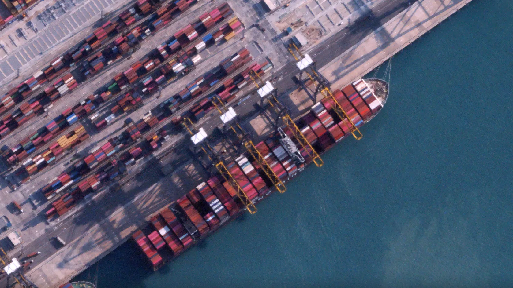
- Port logistics and shipping activity tracking
- Detailed infrastructure inspection
- Compliance verification requiring fine spatial detail
BlackSky Gen-2 - 80cm High Resolution Satellite Imagery
BlackSky Gen-2 delivers up to 80cm resolution satellite imagery, providing strong operational insight for broader area monitoring at a lower cost per square kilometre.
Ideal applications for 80cm imagery include:
- Environmental monitoring and change detection across larger regions
- Regional infrastructure assessment
- Resource and mining site oversight
- Cost-effective repeat collection programs
- Broad situational awareness for disaster response
| Feature | Gen-3 (35 cm) | Gen-2 (80 cm) |
|---|---|---|
| Resolution | 35 cm | 80 cm |
| Best for | Detail-critical applications, individual asset identification | Broader coverage, cost-sensitive workflows |
| Typical use cases | Active construction, ports, logistics, detailed infrastructure | Environmental monitoring, regional resources, post-event assessment |
| Cost | Premium | Cost Effective |
Together, these two constellations give Australian organisations flexibility to choose the right balance of resolution, coverage and cost for each project.
Daily Satellite Revisit Capability Across Australia
One of the most significant advantages of the BlackSky constellation for Australian organisations is daily revisit capability. This means that satellites can be tasked to capture imagery of the same location every day, enabling rapid monitoring across Australia's diverse and often remote geography.
Daily satellite revisit capability unlocks operational benefits that were previously impossible without costly aircraft surveys or on-the-ground inspections:
- Track site progress continuously. Monitor open-cut mining operations, construction sites, and infrastructure projects day-to-day without deploying field teams.
- Monitor post-event recovery. After floods, bushfires, storms or other natural disasters, track the recovery timeline and coordinate response efforts with current imagery.
- Identify unauthorised activity. Detect land encroachment, illegal mining, unapproved construction or environmental violations as they occur.
- Validate contractor milestones. Confirm that resource and construction sector contractors are meeting agreed timelines and specifications using independent satellite evidence.
- Detect subtle environmental changes. Track vegetation health, terrain movement, water body changes and asset displacement over time.
With daily revisit and 24-48 hour delivery, you gain timely operational awareness that reduces risk, supports regulatory compliance and improves decision-making at every level.
How Urgent Satellite Tasking Works: 24-48 Hour Delivery
The satellite tasking process through Terrabit's Albatross platform is straightforward and designed for speed:
- Task submission. You submit your satellite tasking request directly in Albatross by defining your Point of Interest, selecting your preferred resolution (35cm or 80cm) and specifying your collection cadence (Daily, Weekly, Monthly etc).
- Prioritised collection. Your request is prioritised in the next available acquisition window. The BlackSky satellite passes over your target area and captures the imagery according to your specifications.
- Rapid processing. The captured satellite imagery is processed through automated pipelines to produce analysis-ready products.
- Fast delivery. Finished imagery products are delivered to you within 24 to 48 hours of the tasking request - ready to use for decision-making, reporting or further analysis.
This turnaround supports urgent environmental response, active mining reporting, infrastructure monitoring and compliance verification without delay.
Satellite Tasking vs Archive Imagery: When to Use Each
One of the most common questions in earth observation is whether to use archive satellite imagery or to task a satellite for new collection. The answer depends on what you need and how time-sensitive your requirements are. For a detailed comparison, see our guide on archive vs tasking.
When to use archive satellite imagery
Archive imagery is the right choice when you need historical baselines, long-term trend data, or imagery for locations where recent captures already exist. It is typically less expensive than tasking and available 3-5 days with premium processing from Terrabit.
Common archive use cases include: baseline environmental studies, historical land-use comparison, long-term vegetation or terrain monitoring, and research applications where image age is not critical.
When to use urgent or premium satellite tasking
Satellite tasking is the right choice when you need current updated or regular data, when no suitable archive imagery exists or when timing is critical to your operations or compliance requirements.
Common tasking use cases include: dynamic event monitoring (bushfires, floods, storms), compliance and regulatory reporting deadlines, confirmation of current on-ground conditions, active construction or mining site documentation and rapid change detection.
| Use Case | Archive Imagery | Urgent Tasking | Premium Tasking |
|---|---|---|---|
| Baseline studies | ✅ | ❌ | ✅ |
| Historical comparison | ✅ | ❌ | ❌ |
| Long-term monitoring | ✅ | ✅ | ✅ |
| Dynamic events and disasters | ❌ | ✅ | ❌ |
| Compliance or reporting deadlines | ❌ | ✅ | ✅ |
| Confirmation of current conditions | ❌ | ✅ | ✅ |
Satellite tasking ensures certainty. You are securing the specific imagery you need rather than hoping it already exists in an archive.
Satellite Tasking Applications Across Australia
High-resolution satellite imagery combined with rapid tasking delivery transforms operational visibility for organisations across multiple Australian sectors.
Bushfire and Flood Response
In environmental emergencies, satellite tasking provides rapid access to imagery showing the extent of damage, the progression of active events and the status of critical infrastructure. Emergency management teams use tasked satellite imagery to assess bushfire burn scars, map flood inundation extents, coordinate recovery efforts and communicate impact to stakeholders.
Australia's bushfire seasons and flood events demand near real-time awareness over vast areas - exactly the scenario where satellite tasking with daily revisit capability delivers the most value.
Mining and Resource Operations
Mining operations across Australia rely on satellite tasking to track pit progression, monitor overburden movement, assess haul road conditions, document disturbance and inspect tailings storage facilities. Port activity monitoring, stockpile measurement and construction progress verification are also common satellite tasking applications in the mining sector.
With 35cm resolution from BlackSky Gen-3, individual vehicles and pieces of heavy equipment are identifiable, supporting detailed operational analysis without site visits.
Infrastructure and Construction Monitoring
Infrastructure and construction projects benefit from regular satellite tasking to document project progress against timelines, manage contractor accountability, verify milestones and communicate updates to project stakeholders with visual evidence.
From major road and rail projects to energy infrastructure and urban development, tasked satellite imagery provides an independent, repeatable record of on-ground conditions.
Rapid Change Detection
Rapid change detection using satellite tasking identifies land-use changes, property boundary encroachment, unauthorised construction, vegetation clearing and other compliance issues. Organisations responsible for environmental management, planning enforcement or asset protection use repeat satellite imagery to detect and respond to changes as they occur.
Satellite Tasking Options
| Tasking Option | Resolution | Satellite Asset(s) | Best For |
|---|---|---|---|
| Urgent Tasking (Gen-3) | ~35cm | BlackSky Gen-3 | High-detail requirements: construction progress, industrial inspection, infrastructure mapping |
| Urgent Tasking (Gen-2) | ~80cm | BlackSky Gen-2 | Rapid turnaround at lower cost: inspections, environmental monitoring, regional assets |
| Premium Tasking (WorldView Ultra-High Resolution) | ~30cm | WorldView Legion (x6) + WorldView-3 | Very high resolution, wide-area monitoring, detailed change detection. Suitable for weekly or fortnightly programs |
| High Resolution Tasking (50 cm Class) | ~50cm | WorldView-2, GeoEye-1 | Strong balance of cost and resolution for recurring monitoring and asset inspection |
| High Resolution PAN Only | ~50cm (Pan) | WorldView-1 | Panchromatic-only collection for mapping, elevation modelling and cost-effective detail capture |
| Premium Tasking (KOMPSAT Optical) | 40-55cm | KOMPSAT-3, KOMPSAT-3A | High resolution, cost-effective optical monitoring. Ideal for fortnightly or monthly programs |
| All-Weather Tasking (SAR) | ~1m (mode dependent) | KOMPSAT-5 | Day/night, cloud-penetrating radar imagery. Ideal for wet season monitoring, ground movement, infrastructure stability and disaster response |
How to Task a Satellite Through Albatross
Inside Terrabit's Albatross platform, you can manage the entire satellite tasking workflow:
- Define your AOI. Draw, pick a point or upload your area of interest directly in the platform.
- Submit a tasking request. Request urgent or standard satellite collection with your preferred parameters.
- Track progress in real time. Monitor satellite acquisition status, revisit timing and delivery milestones.
- Access delivered products. Download ready-to-use satellite imagery for analysis, reporting or integration into your GIS workflow.
- Get direct support. Contact the Terrabit team for priority tasking coordination, feasibility assessment or technical consultation.
Alternatively, speaking directly with our team can kick off the process urgently.
Frequently Asked Questions About Satellite Tasking in Australia
What is satellite tasking? Satellite tasking is the process of instructing a satellite to capture new imagery over a specific Area of Interest at a designated time. Rather than relying on previously captured archive imagery, you request a fresh collection tailored to your project needs - including location, resolution, timing and collection conditions.
How quickly can I receive satellite imagery after tasking? Through Terrabit's Albatross platform using BlackSky constellations, satellite imagery is typically delivered within 24 to 48 hours of submitting a tasking request. Delivery speed depends on satellite availability, weather conditions and collection priority.
What is the difference between satellite tasking and archive imagery? Archive imagery consists of satellite images captured in the past and stored in a database. Satellite tasking involves requesting new imagery collection for a specific time and location. Tasking gives you control over when and where imagery is captured, while archive imagery is limited to what has already been collected.
What resolution satellite imagery is available for tasking in Australia? Terrabit offers satellite tasking at 35cm resolution (BlackSky Gen-3) for detail-critical applications and 80cm resolution (BlackSky Gen-2) for broader coverage and cost-sensitive workflows. Both options support daily revisit capability across Australia.
What industries use satellite tasking in Australia? Satellite tasking in Australia is used across mining and resource operations, infrastructure and construction, environmental management and disaster response, agriculture, defence, government compliance and regulatory enforcement, and urban planning sectors.
How does daily satellite revisit capability work? Daily revisit capability means a satellite constellation can image the same location every day. The BlackSky constellation achieves this through multiple satellites in coordinated orbits, enabling near real-time monitoring of change over time. This is particularly valuable for active mining sites, construction projects, environmental events and ongoing compliance monitoring.
Can I use satellite tasking for bushfire and flood response in Australia? Yes. Urgent satellite tasking is one of the most effective tools for disaster response. Tasked imagery provides rapid assessment of bushfire burn areas, flood inundation extents, infrastructure damage and evolving environmental conditions - often within 24 to 48 hours.
Why Work With Terrabit for Satellite Tasking in Australia
Terrabit combines direct satellite tasking access with deep local expertise, delivering a service tailored to Australian organisations and project conditions.
- Local knowledge. We understand Australian project timelines, regulatory frameworks, seasonal conditions and the unique challenges of operating across remote and diverse landscapes.
- Industry experience. Our team has extensive experience supporting mining, infrastructure, environmental and government sectors with satellite imagery solutions.
- Full lifecycle support. From feasibility assessment and AOI definition through to ordering, delivery and ongoing tasking program management, Terrabit provides end-to-end assistance.
Satellite imagery is becoming a standard operational tool for Australian organisations. As satellite constellations expand and tasking platforms become more accessible, the combination of daily revisit capability and 24-48 hour delivery is enabling teams to respond faster, manage assets more effectively and track change as it happens.
Whether you need satellite imagery for mining operations, infrastructure projects, environmental monitoring or emergency response, Terrabit and our satellite partners deliver the speed, resolution and reliability Australian organisations depend on.
Ready to task a satellite? Contact Terrabit and submit tasking - or ask about Albatross and task directly from the platform.