Loading...
Request and manage geospatial data on demand through a unified enterprise portal. Streamline workflows, collaborate with your team, track orders and access data across your entire portfolio with full governance oversight.
Discover how Albatross empowers your organisation to efficiently manage geospatial data at enterprise scale.
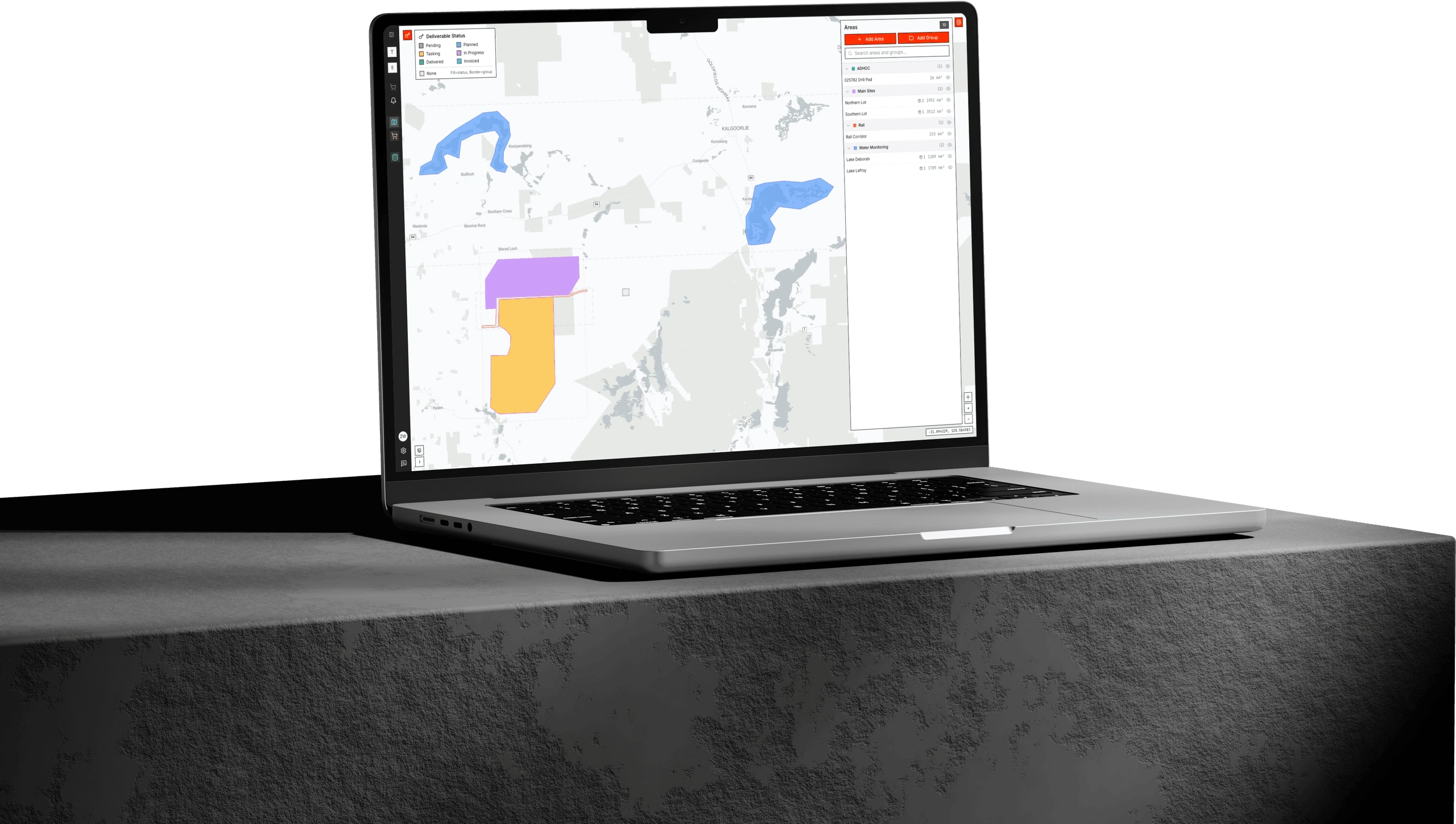
Get a comprehensive view of your entire geospatial portfolio from a single dashboard. Monitor orders, track delivery status and access historical data with intuitive visualisation tools designed for enterprise workflows.
Search and order from extensive satellite imagery archives with powerful filtering capabilities or task new imagery directly through the platform. Define your area of interest, specify parameters and place orders with transparent pricing.
Track your orders from submission to delivery with full visibility. Access delivered data directly through the platform with secure download options and viewing of data within the browser.
Enable your entire organisation to work together effectively with permission-based access controls, shared workspaces, and collaborative ordering workflows. Maintain governance oversight while empowering teams across departments.
How it comes together
From tasking to analytics, Albatross ties every step of the workflow together.
Data Acquisition
Order imagery across a wide range of satellite sources through one agnostic interface.
Data Processing
Standardised, analysis-ready outputs that slot straight into your pipelines.
Data Catalog
A living archive where every product is stored and queryable by location and time.
Analytics
ML-assisted digitisation, change detection and prediction built on top of the catalog.
Stage 01
Data Acquisition
Stage 03
Stage 02
Stage 04
Platform
Albatross
Access imagery from leading commercial and public satellite constellations through a single unified platform.


An enterprise geospatial data management platform is a centralised software solution that enables organisations to order, access, store, and collaborate on satellite imagery and spatial data at scale. Albatross provides team-based workflows, permission-based access controls, and governance oversight to streamline geospatial operations across departments and projects.
Albatross streamlines the satellite imagery ordering process by providing a unified interface to search multiple satellite archives, define areas of interest, filter by parameters like cloud cover and resolution, and place orders with transparent pricing. Teams can collaborate on orders, track delivery status in real-time, and access delivered data directly through the platform.
Albatross provides access to imagery from multiple satellite constellations and data providers through a single interface. This includes high-resolution optical imagery, multispectral data, and archive collections spanning years of historical coverage. Contact our team for specific constellation availability in your region.
Albatross implements enterprise-grade permission-based access control that allows administrators to define individual user permissions, create team workspaces, set budget limits, and establish approval workflows specific to how your organisation operates. This ensures data governance compliance while enabling teams across your organisation to collaborate effectively on geospatial projects.
Centralised geospatial platforms like Albatross serve organisations across mining, agriculture, government, infrastructure, insurance, and environmental monitoring sectors. Any enterprise requiring consistent access to remote sensing data, team collaboration capabilities, and governance controls over spatial data assets can benefit from the platform.
We offer two order types to suit your project needs: Rush Orders are delivered within 24 hours of data receipt and include automated orthorectification and image processing with data populated directly into the Albatross platform-point tasking is available for time-critical new captures. Premium Orders are delivered within 3-5 working days of data receipt and include our full in-house processing suite: colour balancing, mosaicing, orthorectification to control and custom output formats. For archive data, this means 3-5 working days from order placement. For tasking orders, processing begins once your area of interest has been fully captured.
Archive ordering allows you to search and purchase existing satellite imagery from historical collections, often with immediate or rapid delivery. New tasking involves scheduling a satellite to capture fresh imagery over your area of interest on a future date. Albatross supports both workflows, giving you flexibility to choose the best option for your project timeline and requirements.
Ready to streamline your geospatial data management? Our team will walk you through the platform capabilities and help you understand how Albatross can transform your workflows.