Vantage™ and Pulse™ programs aim to combine high-resolution imagery with near real-time global revisit.
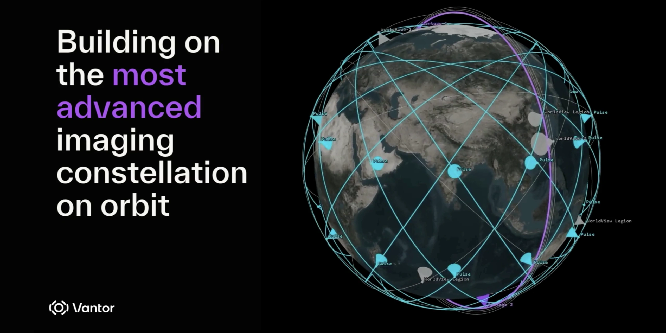
Vantor has announced a major expansion of its Earth observation constellation, introducing two new satellite classes designed to combine high-resolution imaging with high-frequency global monitoring.
The announcement marks a significant step toward addressing a long-standing limitation in commercial satellite imaging: the trade-off between image detail and revisit frequency.
Dual-satellite approach: Vantage™ and Pulse™
The expansion introduces two complementary systems:
Vantage™: next-generation satellites delivering 20cm-class imagery, expected to begin deployment as early as 2029
Pulse™: a fleet of 40cm-class satellites designed for persistent, high-frequency monitoring, with deployment targeted from 2027
Together, these systems aim to create a commercial architecture capable of delivering both high spatial resolution and near real-time temporal coverage.
Toward 15-minute global revisit capability
According to the announcement, the expanded constellation is expected to significantly increase imaging capacity and revisit rates.
Vantor states that the new architecture could enable imaging of the same location as frequently as every 15 minutes, representing a major shift in how satellite data can be used operationally.
This builds on the company's current capabilities, where its existing constellation can already revisit some locations multiple times per day and capture millions of square kilometres of imagery daily.
Building on the WorldView Legion constellation
The new satellite programs build on Vantor's existing fleet, including the WorldView Legion satellites, which currently deliver 30cm-class imagery and enhanced revisit performance.
These systems have already increased collection capacity and enabled more frequent monitoring across key regions, supporting both government and commercial applications.
Enabling real-time spatial intelligence and AI workflows
The expanded constellation is designed to support Vantor's broader spatial intelligence platform, enabling:
- Continuous monitoring of assets and environments
- Automated change detection at scale
- Near real-time situational awareness
- AI-ready 2D and 3D geospatial data
The company states that this approach will allow customers to move from tasked imagery collection to continuous, automated intelligence workflows.
Industry implications: closing the resolution vs revisit gap
For decades, Earth observation systems have required a compromise between:
- High-resolution imagery (e.g. 20–30cm)
- High-frequency monitoring (sub-hour revisit)
Vantor's dual-constellation approach signals a broader industry shift toward integrated, multi-resolution architectures capable of delivering both simultaneously.
If successfully deployed, this model could reshape use cases across infrastructure and asset monitoring, defence and intelligence, environmental observation, mining and large-scale land management.
Timeline and outlook
Pulse™ (40cm, high revisit): expected from 2027
Vantage™ (20cm, ultra-high resolution): expected from 2029
While both systems remain in development, the announcement highlights increasing demand for persistent, high-resolution global monitoring and the growing role of AI-driven geospatial intelligence.
Sources
Vantor – Constellation Expansion Announcement (April 2026)